2008/11/03
2008/11/02
Ai Wei Wei
 A stormy morning. By the Thames at the Albion Gallery, in the wavy complex designed by Foster came our first encounter with the works of Ai Wei Wei. In China and beyond, Ai Wei Wei becomes a figure representing Chinese avant-garde. His fame escalated after he collaborated with Herzog de Meuron on designing Beijing's Olympic Stadium.
 Nothing rebellious like his former pieces. Bamboos, a symbol of old tradition and new construction, stood in an architectural fashion that lure spectators into the heart of an abstract scaffolding. Perhaps the empty chairs in the air signify Ai's attempt to immortalise the workers in the age of massive construction. Perhaps they represent the sense of loss for traditional China. We will have another chance to see his work at Venice Biennale in two weeks of time.
2008/10/30
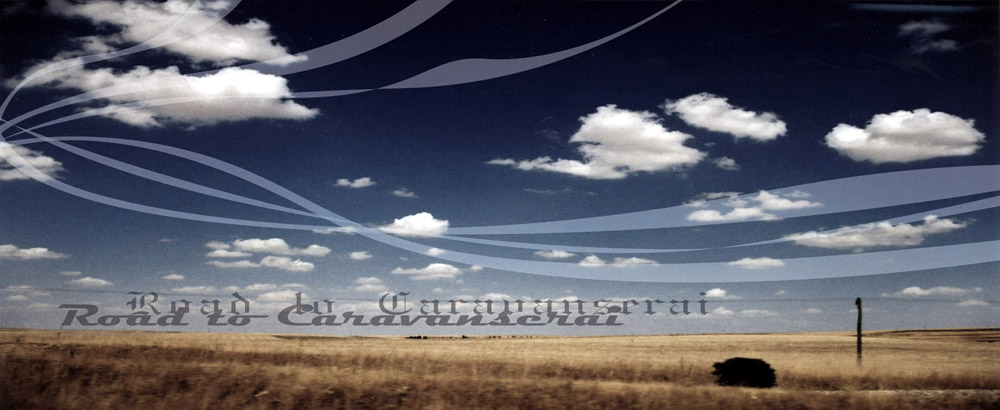
Road of Tajines_7
 2008.10.11
In fact, this is the last full day of our Moroccan holiday. After the Sahara, the Dades and Todra, and the Atlantic, snow-capped mountains of the High Atlas were the next destination in our itinerary. It was no easy journey to reach the mountains without hiring a car or taxi. We started off the day with a 40 minutes walk from Djemma el Fna to a highway south of the city, to seek for a public bus that would perhaps bring us to Asni. We were instructed by a local to get onto a bus bounded southwards. The bus ran for over half an hour. We were half asleep throughout most of the way. By the time we were fully awakened, sunbreaks appeared in front of us and we could see the snow-capped mountain range of the High Atlas. Because of the thick clouds, most of the peaks were pretty much hidden.
The bus dropped us at a village, probably Tahnaout, at an intersection where a group of locals were waiting for mini-buses and shared taxis. We joined them at the roadside and ended up finding ourselves cramped like prisoners at the back of a mini goods van. I was the last to get on the van. Luckily two old men were kind enough to squeeze out 1/4 of a seat for me, while HC, MC and SH all cramped in one corner. It was an exciting half hour ride uphill zigzaging along narrow mountain roads. HC fell asleep almost as soon as he sat down. MC, a local old man and I exchanged smiles everytime HC's head fell onto the shoulders of the old man. Crowned as the biggest saturday market at this part of the High Atlas, saturdays in Asni have always been a gathering time among the locals. We strolled through the market from the end that sells tajine pots to the opposite that sells donkeys and horses (a). Nothing caught our eyes. At the exit, we hired a taxi for Imlil, a tiny village that serves as a popular base for trekking.
Jbel Toubkal soon fell in sight as our taxi left Asni. With 4167m, it is the highest peak in North Africa. The snow-capped peak was well hidden behind clouds. The taxi driver dropped us off at a cafe and agreed to pick us up in two hours of time. We followed a path into the Toubkal National Park. On our way to search for a good view of Jbel Toubkal, groups of children and locals waved at us as we passed by Berber settlements. On a dried stream bed, we ascended towards Toubkal for a short distance, climbed up a few terraced fields and reached a large rock in front of a stone retaining wall. We went no further but climbed on the rock one by one to take photos of the mountain, as well as ourselves (b)(c). This stone retaining wall and a semi-hidden Jbel Toubkal concluded our day excursion.
After we returned to Marrakech, we made a last effort to shop for souvenirs in the souk (d). As I used up my last Moroccan dirhams, I bought nothing but a box of mini-French/Moroccan pastries for my colleagues in London. That night, we skipped supper altogether. MC didn't fell well and went to bed early. SH, HC and I bought a box of mini-pastries and played some games of Big2 to determine who got to eat.
2008/10/29
Road of Tajines_6

2008.10.10
I have never intended to visit Essaouira. Yet, after some days of sand and dust, it seemed rather tempting to relax ourselves at a seaside resort by the Atlantic. At the CTM bus station, we encountered a mid-aged Hong Kong couple. Having travelled to almost all nations in Euroasia, they were starting a 3-month journey across North Africa and the Middle East. On the bus, a German woman from a town near Frankfurt sat behind me. She chatted with me about her travel experiences in China and how her nephew had been having a great time studying in Shanghai.
The blue ocean had finally came in sight after almost three hours of bus journey. Immediately after we arrived, we headed southwest towards the old walled city and the harbour. We strolled through many street markets, with vendors selling all kinds of fruits, meat and household goods. A small laneway off the main shopping street led us into a courtyard filled with seafood vendors, selling all sort of fresh catches, from seafish to shellfish. We didn't stay long in the market as loads of tourists flocked in one group after another to take pictures. We found our way to the southern end of the walled city, exited a gate, and reached a junction point between the fishing harbour (a) and a long stretch of beach. At this junction point stood about a dozen of outdoor seafood eateries. We took our time to pick and at last landed on one of them (they all looked the same) to treat ourselves with some local seafood. We enjoyed the process from picking the seafood to filling up our tummies, despite the Moroccans hardly put any effort to prepare the dishes, just by adding some salt and grilling everything in the fire, without even cleaning the fish. At the end, after days of meat and bread, we were all pretty satisfied with a change of taste (c: photos from HC's camera).
After the seafood, we stayed at the harbour to shoot some pictures, lingered at the beach for an hour, toured the old city for another hour and a half where I have done some shopping, before headed back to the bus station for an evening bus to return to Marrakech.
Road of Tajines_5
 2008.10.09
The wind was blowing strong. A mini dust storm was visible down at the river valley as we approached the ancient mud fortress of Ait Benhaddou. We stepped out the shared taxi and could barely walk against the gust. Although in the middle of nowhere, Ait Benhaddou is a popular tourist attraction in Central Morocco. David Lean's Lawrence of Arabia, John Huston's The Man who would be King, Martin Scorsese's Kundun, and the more recent The Mummy, Gliadator and Alexander, and many other films have all been filmed at this well-preserved and renovated fortress (a).
We made our way to one of the entries of Ait Benhaddou after crossing an almost dried-up river on stepping stones. Since all entries into the fortress have to transpass private homes, we had no choice but to pay an "entry fee" to one of the local family. On the way up to the kasbah, we encountered a group of Hong Kong tourists. It was extremely windy when we reached the top. We didn't stay long, despite the arid landscape beyond the fortified walls are quite spectacular.
Our hired shared taxi brought us back to Ouarzazate. We had about 45 minutes before the CTM bus departed for Marrakech. We took our backpacks with us to the main town square and chose an outdoor cafe. Each of us ordered an egg omelette, three omelette Berber and one omelette fromage. The owner and his Berber cook did took their time to prepare the food, despite HC went to chase them after 10 minutes and we constantly stared at them from our table. We were left with merely two minutes to finish our fresh cooked omelettes on hot pans before we dashed to the bus station nearby.
The CTM bus turned up 40 minutes late. It was a great bus journey that winded through some spectacular mountain ranges of the High Atlas. The experienced driver seldom slowed down during sharp bends and descends. All we could do was to trust his driving skills and admire the sensational scenery outside the window. The route through the Ourika Valley was the highlight (b).
In early evening, we arrived at Marrakech. From our hotel, we headed towards Djemma el Fna. Filled with street eateries, snake charmers, vendors of all sorts, local shoppers and tourists, the gigantic square was noisy, smelly, smoky and crowded. Recommended by our guidebook, we headed to the third level, a dining balcony of a restaurant that faces the square. That night, we had the best tajines in our entire trip. I had one cooked with beef and plums. The cooked plums was sweet and the beef tender. The swirling ambience of the surrounding permeated our exhausted bodies and lightened our spirit. All of a sudden, bell tolls were heard and a flag was raised at a mosque across our dining balcony. We took our cameras out and peeked over the shoulders of other diners to examine the activities of Djemma el Fna. As our attention had been shifted from the food to the square, our magnificent Moroccan supper had finally come to an end.
2008/10/27
Road of Tajines_4
 2008.10.08
At 08:00, our guide came to pick us up at Hotel Royale. About 45 years of age, our guide AS is very talkative and knowledgeable. We hopped onto his 4x4 and started off our day excursion at our first stop at the kasbah of Ouarzazate. Then we headed east out of the city. Rugged terrains along both sides of the highway. The rocky plateaus, suggested by AS, are renmants of prehistoric era when Morocco was pretty much under the sea. Pointed at a number of refurbished kasbahs, AS told us that many of these ancient mansions are owned by wealthy Europeans, while the rest were owned by local restaurant and hotel keepers who turn the traditional castles into tourist commodities. High mud walls and traditional motifs, these kasbahs now cost roughly 100,000 to 200,000 euros each.
AS began to talk about his company, Ksour Voyages. Owned by a Moroccan and his Japanese wife, Ksour Voyages has good reputation in Ouarzazate, and even aboard, especially in Japan where the Japanese co-owner has written guidebooks about Morocco. Culture, history, geography and then of course, politics, AS was never tired of speaking out his opinions. We discussed about certain political issues, mainly on the conflict between Islamic and the Western worlds. We spoke of George W Bush, Gaddafi, Mugabe, and so on. It was a pleasant talk.
We drove through the oasis of Skoura, a village in a river basin filled with palm and olive trees. Under the shade of thousands of palm trees, mud houses and patches of crop gardens dotted along a labyrinth of narrow streets. Dades Valley, a long and lush-green area along Dades River, was picturesque in the sense that the thriving energy of life from farming villages and palm clusters on the context of barren land reveals nothing but beauty of nature (a). As our 4x4 winded through hills and plateaus, vistas of small Berber villages and farming terraces unfolded after each bend we made. From afar, the mere mud colour of the village houses may suggest a quality of ruins, yet the lush-green crops, palms and olive trees along the river banks reveal the true richness of the region, that is, water.
At about 13:30, we arrived at Todra Gorge, one of the most important tourist attraction in Central Morocco. We had lunch at one of the two restaurants in the gorge, had a short walk in the canyon, where rock cliffs rise to about 150m at both sides, and returned to our 4x4. AS drove us deeper into the gorge for about 15 minutes, on a bumpy road along a tiny glacier stream (b). We passed by a packed minibus with local Berbers heading back to the village deep in the mountains.
We back tracked as we headed back to Ouarzazate. Everyone of us fell asleep in the return journey. With his sunglasses on, AS quietly brought us back to Hotel Royale, after almost 4 hours of driving. Even today I felt really grateful to AS.
2008/10/26
Road of Tajines_3

2008.10.07
As expected, we were waken up by desert flies. This was indeed a good thing. Before breakfast, we walked towards the dunes of Erg Chegaga again (a). We didn't climb to the top as the day before, but managed to walk far enough to get surrounded by sand dunes. HC, MC and I were busy taking pictures. At one point, we indulged ourselves making funny gestures to cast shadows on a faraway sand dune (b). As the desert warmed up, so as the flies (c).
After breakfast, we made our return trip to M'hamid. We had lunch at a local restaurant and boarded a bus for Zagora at 14:00. The 2 hour bus ride turned out to be the harshest experience of public transportation in all my journeys over the past few years. It was way over-crowded with people. The air was stuffy, humid and extremely hot. Before departure, the locals hopped on and off to greet each other and yielded to each other on seat arrangement. Half an hour was gone and the bus had no sign of moving. We sweat from hair to toes but the operable windows were in no way operable. We were cooked for about 40 minutes until the bus finally crawled out the village. After dozens of stops along the highway where people get on the bus from nowhere, at last we reached Zagora.
There was still 4 hours of bus ride to reach Ouarzazate, our destination of the day, but we had no idea if there was any bus available at Zagora. At the end, we decided to pay some extra money to hire a shared-taxi to make up the time and comfort. The 4 hour bus ride was cut to 2.5 hour, thanks to the vintage Mercedes. All four of us squeezed into the back seats, while 2 more locals took the front passenger seat. As evening approached, we drove through the magnificent Draa Valley, the road of Berber villages, ancient kasbah, oases and mountain valleys (d). We drove by sharp turns atop some rocky hills, where Alejandro Gonzalez Inarritu filmed the scene in Babel, in which Cate Blanchett was shot at in a tour bus with Brad Pitt. We reached Ouarzazate in late evening and took the last quadruple room at Hotel Royale.
Road of Tajines_2
 2008.10.06
I sat by the window and watched the sun rose as the bus drove by Berber oases and arid landscapes. We entered Zagora early in the morning. We called the desert tour operator and a taxi was sent to pick up us onwards to M'hamid. At M'hamid, the village where the road ends and the desert begins, we began our desert tour with HC's old friends, the camels (a) (b).
It was a cloudy day in the desert, although according to our guide, there hasn't been a drop of rain in the area in the past 10 years. We switched from camels to 4x4 after 1.5 hour of slow riding, and the camels behaved well. At midday, we stopped at a tiny oasis where our Berber guide made lunch for us.
It was late afternoon when we reached our camp, right by the dunes of Erg Chegaga. Immediately we set off to the dunes by ourselves and decided to conquer the biggest dune in the area, the Erg Chegaga. It wasn't an easy climb and it seemed quite overwhelming from below. We walked along the ridge like ants and slowly climbed to the top in about 1/2 hour. The view on the summit was rewarding (c). We relaxed ourselves on the top (d) and waited for the sunset. A magnificent spectacle of sunset was never a promise as great amount of clouds clustered near the horizon, though the sun did descend low enough to change the hue of the dunes from yellow to orange before it disappeared behind the grey all together.
At the camp, we chat with other fellow travelers, enjoyed some good food prepared by the Berbers, played with a cute cat, played some card games under an oil lamp and as night fell, each of us grabbed a blanket from our tents and set up ourselves to sleep outside in the open area next to the tents. Although there were some clouds but we still had a good time of star glancing. HC was the first to fall asleep. SH and I had some glimpses of shooting stars as the night deepened.
Road of Tajines_1
 2008.10.05
We said goodbye to AC and left my London's flat at 2:30am to catch the 6:00 flight at Luton. After 3.5 hours of flight time and a long and chaotic queuing at the passport control, we finally arrived at the lobby of Marrakech's Menara Airport (a). We immediately felt the heat as we left the plane. Compare to the wet and chilly night of London, the Moroccan sun warmed up our spirit despite we hardly got any sleep.
After all the practicalities of storing our backpacks, securing tickets for the night bus, payment for our desert tour and a quick lunch, we finally entered the old city of Marrakech. From Djemma el Fna, the main square at the heart of the medina, we lose ourselves into the labyrinth of the souk. In mid afternoon, we found ourselves at the door of Marrakech Museum. We stayed in the cafe at the entrance courtyard, purchased 4 bottles of coke and played some big2 and then dosed off and waked up one after another until we all felt it was time to leave. We left without entering the museum. We headed back to Djemma el Fna and found a dessert cafe (b). We ordered some cakes and drinks and allowed time to pass.
We ventured off into the busy and dusty streets of the old city (c), meandered through some markets and arrived at the bus station. Again we found ourselves having a bottle of coke at a small cafe/bar across the station, for the purpose of using their toilet. All people in the cafe had their eyes fixed on the TV showing the last 15 minutes of the La Liga game: Real Madrid vs Espanyol.
At last, we boarded the night bus for the town of Zagora, which situated right at the edge of the Sahara. In the middle of winding through the ranges of the High Atlas, our bus arrived at a stopping point along the mountain road, in the middle of nowhere, for toilet and food. Raw meat were hung at shop front at every eatery along the highway while smoke and smell of cooked meat filled the air(d). The local passengers gathered at their favorite shops and enjoyed their late dinner. This was our first time to see cooking tajine pots in the fire.
Road of Tajines

Time:
2008.10.05 - 2008.10.12
Venues:
Marrakech, Sahara, M'hamid, Ouarzazate, Dades Valley, Todra Gorges, Ourika Valley, Essaouira, Asni, Imlil, Marrakech
Characters:
HC, SH, MC and me (CC)
2008/08/30
Magic Mountain_4
 10_DESCEND
We knew it would be long and tough and we would end up dead tired. I began to feel pain in my legs, since I had slipped and hurt my knees on my way to Obersteinberg, when I ventured off-path a little (big lesson taught). We hiked down the plateau of Oberhoresee back to Schaflager, where we took a last glimpse at the retreating glaciers. From there we took a different path to descend the mountain. We headed east and made a steep descend of 300m to Im Tal. We hiked very slowly and I had to stop and rest pretty often. After all the pain and sweat we reached the level of the rapids (a). At around 17:30 first clouds of the day appeared (b). At Lager we hiked further northeast in attempt to get closer to the Holdri and Talbach Falls. We passed through woodlands and some really muddy paths (c). Then came the mighty glacier falls rumbled down from heaven (d). After the falls, we had nothing in mind but to go downhill as quickly as we could, despite we were both pretty worn-out. After several more river crossings we crawled towards Trachsellauenen (e). By around 19:00, we finally got to Trachsellauenen, the last stop before reaching the village of Stechelberg.
 11_STECHELBERG
This was our first chance to truly appreciate the mountains in different time of the day (a). As we walked out the valley, we watched the peaks of Jungfrau turned gold in colour (b). About 30 minutes after Trachsellauenen, more timber houses and pastures appeared along the way. At some occasions, we had to stop and wait for local shepherds to rush their cattle through as they usually blocked off the paths with ropes. 30 minutes before reaching Stechelberg, we had a last look back to the Jungfrau (c). Inch by inch I dragged myself out of the mountains. Seeing the lights and houses of Stechelberg somewhere 100m below us was quite encouraging. At last we made it to Stechelberg at around 20:30. I am convinced that we had taken far longer than any other hikers to finish the trail. Given this was our first time, plus the luck of having perfect weather the entire day, we were both proud and happy as we entered the village. We ended up having a big dinner of sausage soup, fondu and steak at Stechelberg before heading back to Gimmelwald by bus and cable-car. Outside the restaurant while waiting for the last bus of the night, we finished the day with some star-watching.

Magic Mountain_3
 7_GLACIERS
Half an hour beyond Obersteinberg we reached a plateau at Schaflager. Traces of retreating glaciers dotted along the the foot of adjacent mountains. Clear sighting of disappeared glaciers raised every hiker's deep concern. Bare glacial deposit exposed as ashes beneath tiny bits of thinning tongues. Some experts warned that Alpine glaciers would disappear entirely by 2050. Judging by what we had seen (despite the time of high summer), perhaps the experts were already over-optimistic.
 8_OBERHORESEE
Another hour of steep climb took us to our final destination - a tiny glacial lake at the altitude of 2065m, Oberhoresee (a). As inexperienced hikers, we were overjoyed by reaching this remote destination, almost six hours after we left Gimmelwald. We seated ourselves on a rock, took off our backpacks and jackets. Right away we found ourselves busy taking photos in front of the tiny turquoise lake, in which the Jungfrau imprinted her sacrosanct reflections (b)(c)(d). No one among the dozen or so hikers who rested around the water dared to take a dip into the close-to-freezing water. Some hikers took out their food, some their binoculars, and some, including AC, preferred to take a nap on a rock - an experience that she later described as "eyelid and snow-mountains" (all you can see are the snow-capped mountains when you open your eyes, as simple as that).
 9_ALPINE HIGHLANDS
Behind Oberhoresee stood the summit of Breithorn and her glaciers. For 30 minutes we lingered on this peaceful highland around the lake (a). Wild Alpine flowers, mainly in white, purple and yellow, carpeted the ground up to the snowline. Honeybees buzzed and butterflies fluttered up and down (b). Again our hearing was dominated by the sound of running water, mainly from the glaciers of Breithorn and beyond. At Oberhoren we got a chance to cross a small bridge and headed up to the hut at Schmadrihutte(c). That would take us probably another 60-75 minutes. We didn't take it. We had to conserve energy for the long descend ahead. Mini waterfalls cascaded down the mountain, along a path that led us to loop around the highland (d). At around 15:30, we decided to journey back down, as we had no plan to stay the night outdoor.
Magic Mountain _2
 4_PATH TO OBERSTEINBERG
At the altitude of around 1800m we reached an open slope under the steep cliffs of Tanzbodeli. We followed the signed pathway towards the east side of Tanzbodeli and reached an overhanging pathway where we came face to face with the majestic Jungfrau (a). Glacial water streamed down the snowline, making us wonder how much longer before all these glaciers are gone (b). We came so close to these famous peaks all by ourselves, as if the two of us were the only visitors to the 'magic mountain'. Comparing to the year-round busy Jungfraujoch mountain railway station on the other side of the summit, where I visited ten years ago with my parents, this Jungfrau in front of us stood as if a different mountain (c). The high path ended at another green slope fenced off for cow grazing (d). This was the point where I mis-read the map and thought we should have followed a higher path. As I attempted to find our way through the grazing slope to reach my imaginary higher path, a shepherd appeared from nowhere and instructed me the right way - a short descend below the slope to the restaurant of Obersteinberg.
 5_LUNCH
 We reached Obersteinberg at around 12:45. On a bench facing the Talback Falls, we had our lunch - 2 cans of corn-beef, 1 can of tuna and 1 loaf of bread. We bought most of our food supplies the day before from the Migros supermarket at the Basel railway station. We knew that we would not find any grocery shop at Gimmelwald, and nothing would be open in Interlaken and Lauterbrunnen by the time we arrived. Unbeatable scenery. Simple but delicious food. Pure glacier water. Zero complain.
 6_STREAMS
 After lunch, we turned our back towards Jungfrau and made our way further south towards the glaciers of Breithorn. We passed by numerous waterfalls (a), crossed the Tschingel Litschina (b) and other glacial streams at several occassions. As we approached closer to this deep end of the Lauterbrunnen Valley, the peaks of Jungfrau and Monch formed a magnificent backdrop behind us. At this time of the day, this west face of the mountains was completely bathed in the afternoon sun (c).
2008/08/28
Magic Mountain_1

1_ARRIVAL
75 minutes of bus ride, 150-minute-long wait at London Stansted, 75 minutes of flight time, 120 minutes of ICE service, 20 minutes of mountain railway, and we still hadn't reached our destination. By 20:30 we reached Lauterbrunnen and had our first glimpse of the mountains. Rain began to pour as we stepped out of the station. We had an hour to kill before the next bus arrived. Despite the rain and darkness, we strolled to the southern end of the main street to see the Staubbach Falls, one of the valley's many glacier waterfalls. The bus finally came. In 20 minutes it took us deep into the Lauterbrunnen Valley to the cable-car station at Stechelberg. In complete darkness, we made a short lift from the valley floor to Gimmelwald, our final destination of the day at 1370m. Flocks of tourists pass by Gimmelwald everyday without delay, enroute to the panorama restaurant at Schilthorn, where a few scenes of 007 were shot back in late 1960s. By around 22:20, we finally arrived at our pension. London-Stansted-Basel-Interlaken-Lauterbrunnen-Gimmerwald. All it took was 13 hours from London Victoria to the heart of the Swiss Alps.
 2_MORNING
A peaceful night in the timber chalet.
Next morning, we woke up at around 06:00. Out the window we watched the sky gradually brightened, and discovered the beauty of the surroundings - mountains, cliffs and waterfalls. At 07:00 we went out for a stroll and were exhilarated with the clear sky (a). Local farmers were already starting their days. Bell tone of goats and cows. And the sound of waterfalls and rapids. It had been so long since we last enjoyed such tranquility and freshness of the nature. After breakfast, at 08:30 we began our day-long journey into the mountains. We exited the village (b) and descended to the rapids below where glacial water continue to carve the river valley. A black cat with thick fur followed us from halfway, until we crossed the river that he finally gave up.
 3_ASCEND
Our day's first challenge began immediately after the crossing. For the next two hours or so we wound through dense evergreen forest and continuously ascended up the mountain for about 500m in altitude (a). As the mist gradually cleared away in the Lauterbrunnen Valley, our morning excitement was overwhelmed by physical exhaustion (b). Though freshness of the air, fragrance of the soil and the sound of waterfalls made our bodies relax as ever. At occasional clearings we looked across the valley to the north, where the village of Gimmelwald appeared like a dozen tiny timber toy houses on a lush-green hillside (c). By comparing where we stood to the level of Gimmelwald, we tended to estimate roughly how far we had made uphill.
Beijing 2008

I have missed the closing ceremony while hiking the Swiss Alps, and I guess it's kind of late to say anything about the Beijing Olympics, other than I am super happy on how our fellow Chinese have managed a great event.
Don't know (and will never know) what the experience would be like if I were to witness and participate this spectacular event in Beijing... just like what we, a group of secondary school friends and Chinese diaspora, once made a casual promise in 2001 that we would go to Beijing for the Games in seven years of time. Seven years have passed. Each of us has pursued a distinct path of life. The Olympics opening ceremony has been spectacular as promised. What turned out unexpected are perhaps the changes that each of us has gone through.
Farewell, our growing years.
2008/07/22
Danish Architecture
Two venues, one subject: Danish sustainable architecture - one of the 28 Embassies Project exhibitions of London Festival of Architecture 2008. While "sustDANEable" showcased models, videos and drawings of various Danish sustainable projects in the embassy's parking garage; Co-evolution, the winner of Venice Biennale 2006, exhibited interesting Sino-Danish collaboration on sustainable urban development in four Chinese cities: Xian, Beijing, Shanghai and Chongqing, in an old college building by the Thames.
 "SustDANEable" exhibition at the Danish Embassy
 Co-evolution: Sino-Danish sustainable urban development in China
 Model of the Magic Mountains project in Chongqing
2008/07/19
Detour
Just want to share with you. As part of London's architecture festival, Detour, a multimedia exhibition performed through a traditional peepshow in an old mansion, introduces 18 architectural structures along some of the most picturesque national tourist routes in Norway. Not the best design show, but a great promotion for the Norwegian natural beauty.
Detour from K F C on Vimeo.
Detour from K F C on Vimeo.
White Cliffs
Last Sunday, we went hiking along some famous chalk cliffs in Southern England. Fair weather, if not a little too windy. Infinite sky, white cliffs, seagulls, sheep, wild flowers, the Channel. We started at Seven Sisters Country Park at 13:00 and reached our final destination at the resort town of Eastbourne at around 19:30.
 Seven Sisters Cliffs
 "Danger, cliff erosion"
 Lighthouse below Beachy Head, the highest chalk cliff in England

Birling Gap, intermediate resting place for the 16km hike
 Eastbourne Seafront, our final destination
 Seven Sisters Cliffs
 "Danger, cliff erosion"
 Lighthouse below Beachy Head, the highest chalk cliff in England
Birling Gap, intermediate resting place for the 16km hike
 Eastbourne Seafront, our final destination
2008/07/06
Viva Espana!!
 Road to Madrid, 2003
 Segovia, 2003
It's their year! Both for Nadal and the Spanish national football team! What a great display of attacking football last week at Vienna's Euro 2008 final, and what an epic win for Nadal to beat Federer today at Wimbledon. Today's game was unbelievably long. I don't know how Nadal and Federer can cope with the pressure throughout. The game has lasted for almost five hours! We thought of going to Wimbledon to watch it live (on big tv screens outside the stadium), but were discouraged by the fact that we had to queue for a ticket and a spot super early in the morning. Thus, we decided to watch it at home instead... Viva Espana! Let's hope Nadal can continue his great form later in the US Open, while Casillas, Torres, Fabregas and the likes can play some great football in South Africa in two years of time.
2008/07/05
Battersea Power Station


A well-known (but abandoned) building designed by Giles Gibert Scott, who was also the architect for Bankside Power Station (now the Tate Modern). The Battersea Power Station is probably one of the most iconic buildings along the Thames, and for many, including me, it's one of the most beloved structures in the city. It has become a favorite spot for amateur photographers, a cultural icon as it has appeared in works of many artists, film makers (Hitchcock and many others) and in MTV and on record covers of rock bands (such as Beatles, Pink Floyd, etc.), and a controversial site for real estate redevelopment. Architect Rafael Vinoly was hired a year or two ago, and recently he has presented his masterplan (N attempts to revitalize this site of collective memory since the early 80s), which involves renovation of the brick building and a new skyscraper and mix use complex alongside. New apartments, shops, hotel, bars, and offices would certainly transform the badly deteriorated architectural icon into a feast for real estate developers. Whether his proposal can balance the taste of politicians, the greed of the developers and the heart of the public, we will soon find out.
Street Art, London 2008
Tate Modern, June to now

Waterloo Taxi Tunnel, May


Street Art has been a big hit in London in the past two months. First street artists from all around the world came to transform a taxi-parking tunnel at the Waterloo Train Station into a huge public gallery. Then the Tate Modern came along to hold a special exhibition on street art and provide its massive brick facade for gigantic pieces made by internationally renounced street artists. If there hasn't been Banksy in the past few years to stir up the controversy, how differently will the public and the mass media evaluate these great and often meaningful works that they once call graffiti?
2008/07/02
One Thousand Year of Solitude
Longprayer, a sound installation in the Lighthouse at Trinity Buoy Wharf, east of London. If everything goes as planned, the piece will last for exactly 1000 years.
With a computer program continuously editing the original, an audio recording of a 20-minute Tibetan prayer has been playing without stoppage and repetition since 1st January, 2000, and will continue to do so until the last day of 2999.
We visit the lighthouse as part of the London Festival of Architecture last Sunday. Trinity Buoy Wharf, including the lighthouse and container cities, was used as an exhibition ground to house several installations and architectural exhibitions.
* * *
Infinite blue sky. Endless moving clouds. Curvy silhouette of the window panes. A dreamy and laid back afternoon. Trembling reverberations of the Tibetan singing bowl in a surreal interior of the lighthouse did something funny to my sense of time, as if the very moment could last forever, as if within a second a thousand years had gone by. Subconsciously my imagination jumped through 992 years to the end of 2999, searching for whoever may be present at the same spot, in the lantern room of the Trinity Buoy Lighthouse, across the Thames from North Greenwich, east of London, listening to the grand finale of Longprayer, probably at a rainy night. In a thousand years of time, will the Thames still run in front of the Trinity Buoy Wharf? Will the only lighthouse of London still standing? Unlikely.
Eternity from K F C on Vimeo.
2008/07/01
Dummies


 A Sunday afternoon in spring. An empty arcade in the city. A few dummies in the absolute silence.
Bruges 2007


A grey chilly day. A melancholy little old town. Here everything makes you to believe that the eternal beauty of Bruges is a legacy of its glorious past, when medieval merchants has transformed the once sleepy town into a prosperous port city famous for its wool and cloth trading. Full of pleasure and joy, you stroll along centuries-old colonnades, cross ancient stone bridges and wind through tiny intricate alleyways, fulfilling your long desire to go back in time. Here nothing reveals the 500-year decline of the town after the commercial port has been abandoned. Fortune receded but proved to be a cycle. A slight Potemkinist touch and a long-lived effort of preservation, Bruges has found a new story of success since late 19th century, being one of the earliest tourist destinations in Europe.
Here the real master is you and me, my fellow tourist.
2008/06/29
Subscribe to:
Posts (Atom)